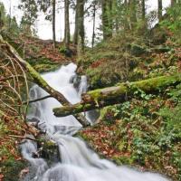
Start / finish: car park at the Ettlingen outdoor pool. From there “bei der Hell”, past the Horbachquell biotope on the panorama path along the tree line to Oberweier. Left turn after water reservoir Oberweier towards Carl-Schöpf-Hütte. Downhill along the tree line into the Moosalbtal. Be careful when crossing the L 613! Along the “Wässerwiesen”, descending on the right, block trail to Schöllbronner Mühle, crossing the K 3553 (be careful!). Along the Moosalbtalweg to the “Toten-Mann-Stein”, left up, single trail to Schöllbronn to the junction to the right (Solbrunnenweg) to the “Windwiesen”. Take the singletrack descending to the right to the Alb valley, climb towards Spessart over the "Heuweg" (road) at the sewage treatment plant level to the "Oberen Tabakmühlenweg", which leads back to the starting point or the possible crossing at the tennis court over the Alb bridge to the Wattkopf.
further information / maps:
City of Ettlingen
city information
Tel .: +49 (0) 7243 / 101-221
Fax .: +49 (0) 7243 / 101-430
www.ettlingen.de info@ettlingen.de
Author: Nico Weisenburger