Explanation of the new Black Forest uniform route signage
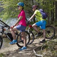
The Black Forest with its many thousands of kilometers of hiking trails has always been a paradise for hikers. A new system of paths, which is implemented uniformly throughout almost the entire Black Forest, now offers even more attractive opportunities to enjoy the fresh mountain air, the overwhelming nature and the Black Forest hospitality.
With the new signposts, we have made a big step from signposting circular routes for individual locations to so-called destination signposting. This means that you no longer follow the red number 10, a green dot or a letter. Rather, a sign tells you exactly where you are and how far it is in which direction to possible destinations.
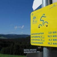
These new signs are very easy to read:
In the center is the name of the respective location, including the altitude above sea level. The destination above in one direction is also the name of the next location, our local destination. The next two destinations are interesting places or landmarks that you can reach in this direction. At the bottom is the long-term destination, usually a place of great interest or the possible end point of a hike with connection to the public transport network. There are also small logos that point out bus and train connections, viewpoints or places to stop for refreshments and more. It is also possible to include logos for themed trails, such as the green deer for “the trail of the red deer.
The focus of the new path system is the yellow diamond. You will be guided by this sign on the way from sign location to sign location. It provides information about the right direction at all intersections. As long as you follow this yellow diamond, you will get to the next sign location and you can get new information there.
The new system was funded by the Black Forest Nature Park and with the support of the Black Forest Association. which continues to use diamond symbols in a different color. For example, the well-known Westweg from Pforzheim adds Basel the red diamond as a marker, the regionally connecting paths such as: B. the border route has a blue diamond. The middle path is further indicated by a red diamond with a white vertical bar and the Ostweg with a red and black diamond. In this special case, these diamonds in red and blue replace the yellow diamond. If you follow such a diamond, you are always on the right path to the next sign.
Put your tours together yourself! If you want to walk a path that takes you back to the starting point, all you have to do is memorize the corresponding sign locations in the correct order. If you want to go to a different destination, simply follow the instructions on the signs.