What could be nicer than an excursion into nature? The Tannenriesen premium hiking trail offers a place of rest and strength and invites young and old on an easy-to-master hike. The smell of wood, moss and meadow, the chirping birds and the many sights - from the largest fir tree in the Black Forest to phenomenal viewpoints - make the idyll perfect.
What can i see
Already at the beginning of the hike you come across a Holzteuchel and some giant fir trees. During the entire hike, you encounter pure nature: bushes offer wild berries to snack on, flowers beguile with their scent, giant firs decorate the edge of the path, soft moss cushions the steps, birds sing their songs. In addition to these wonders of the forest, the Riesentannen hiking trail also offers other sights:
- Kienberg: The Kienberg is a popular destination that offers many opportunities to enjoy the day. On the way up, the art lover will be surprised with handsome sculptures. Once at the top you can let off steam while swinging, cool off in the water treading pool and a mini golf course also provides fun.
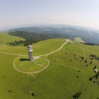
- Duke Friedrich Tower: The Herzog Friedrich Tower rises 25 meters from its position on Kienberg. A breathtaking view awaits you up there. You can see the whole of Freudenstadt, look towards the Swabian Alb and marvel at the Black Forest with its mountains and large forest areas from above. An unforgettable panoramic view.
- Grandfather fir: At 47 meters, the grandfather fir is the mightiest in the Black Forest. She has lived in this piece of forest for around 300 years. With a circumference of 5,30 meters, not every hiker can encompass it ... Can you do it?
- Forest lawn: The forest lawn invites you to have a picnic surrounded by wildflowers and trees. While the tired hikers can strengthen themselves here on the benches, they can enjoy the tranquility of the forest and the sun on their skin.
- rose path: The highest rose path in Germany impresses with the scent of the numerous wild and shrub roses.
What do I have to know?
The circular hiking trail stretches for 8,7 kilometers (with a detour to Großvatertanne about 11), which takes about 3,5 hours. The Tourist Info in Freudenstadt will be happy to provide information on possible abbreviations. This is right next to the Freudenstadt market square (the largest in Germany, by the way).
The mostly unpaved path leads across forests and meadows. The approximately 200 kilometers of altitude that you cover up to the highest point are barely noticeable, so that the path is easy to master even for the youngest.
Where are you going?
The starting point of the route is the Teuchelwald hiking car park or the Schömberger Strasse hiking car park.
If the hike begins at the Teuchelwald hiking car park, you must first follow the Teuchelweg, which immediately leads into the forest.
At the Agnesruhe refuge, we take the Agnesruheweg to the left. On this path you will soon come to the second possible starting point (hiking car park Schömberger Straße).
If you want to take advantage of the area's beauty, you should turn left at the Wölperweg signpost and take a break after about 250 meters on the forest lawn near the Goldene Kugel hut.
Then follow the path back to the Wölperweg and then left into the forest path and left again to the Outer Riviera and finally right.
Once again, the agreement on the circular route is recommended: If you walk straight ahead for 1 kilometer at Lauterhütte, you come to Großvatertanne.
From the Lauterhütte the Baldenhofer Graben turns right. We follow this for three kilometers to the Lauterbad mountain hut.
The upper palm hiking trail leads to the Kienberg (Friedrichshöhe), where there are numerous opportunities for explorers, including the Herzog-Friedrich-Turm.
The last stage leads the hard-working hiker back along the fragrant rose path to the starting point, the Teuchelwald hiking car park.

How do i get there?
- By car:
Hiking car park Teuchel Teuchelwald:
In Freudenstadt take the B28 towards Strasbourg. At the edge of town, about one kilometer after the market square, turn left towards Schömberg. The Teuchelwald car park is on the right.
Hiking car park Schömberger Straße:
In Freudenstadt take the B28 towards Strasbourg. At the outskirts, about one kilometer after the market square, turn left towards Schömberg. After 1,5 kilometers turn sharply left into the parking lot. - By bus and train:
The Freudenburg city train station can be easily reached by S-Bahn.
Various bus lines run from the city station to the Straßburger Straße stop.
From the Straßburger Straße stop it is 200 meters to the Teuchelwald hiking car park.


