![]() Distance: 237,59 km
Distance: 237,59 km
Uphill: 8777 m
Downhill: 8567 m
Type: long-distance hiking trail
Route:
Pforzheim – Bad Liebenzell – Calw – Bad Teinach – Altensteig – Freudenstadt - Alpirsbach – Schramberg – Königsfeld – Villingen/ Schwenningen – Geislingen – Blumberg – Stühlingen – Schaffhausen
More hiking trails in the Black Forest
-
Simon's Schlawinerweg in Simonswald
-
Chamois path Todtnau-Fahl
-
KugelWaldPath Ühlingen-Birkendorf
-
Wilderness adventure trail "Home game for the wild"
-
Bötzinger forest adventure trail
-
"Horneradsch" sensory and forest adventure trail
-
Kandern forest adventure trail
-
Lynx trail in the Black Forest National Park
-
Bötzinger Schambachtal - adventure trail
-
The Hornberger-Schießen-Weg
-
Haslach forest adventure trail
-
The path of happiness in the Murg valley
-
Forest play path in the Schuttertal
-
Wildlife trail in houses
-
Bad Griesbach stalking path
-
Adventure trail in Hausach
-
Small robber path - Robber Hotzenplotz path in Gegenbach
-
Agricultural adventure trail Ottenhöfen - LEPO
-
Kucky's bird life in Lenzkirch
-
Tracer path in Todtmoos
-
The nature discovery trail in Schonach
-
Roman teaching and adventure trail in Hüfingen
-
The Wunderfitzpfad in Simonswald
-
Wendelin Hoopoe in Ihringen
-
Kunigunde's educational cow trail in Lenzkirch-Saig
-
Baiersbronner Holzweg
-
Hinterzarten nature adventure trail
-
Fairytale hiking experience in the realm of the giant fir trees
-
The Geroldsecker Castle Path
-
"How does water live" in Unterkirnach
-
Wolf path
-
Grindenpfad on the Hornisgrinde
-
Magic Land - nature adventure trail on the Kinzigsee
-
On the trail of the Dasenstein Hex
-
Hademar Waldwichtel nature discovery trail
-
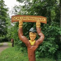
Schlühüwanapfad adventure trail
-
Feldberg gnome trail
-
Magic trail Todtnau
-
Rötenbacher Ant Trail
-
Magic forest path in Bernau
-
Wanderlust in the Black Forest: Find the right footwear for your route
-
Krunkelbach Hut - Gisiboden - Hasenhorn - Todtnau
-
Feldberg: Around the Feldberg - from hut to hut
-
Albsteig - hiking between Albbruck and Feldberg
-
The Murgleiter - an award-winning long-distance hiking trail
-
Canyon Trail
-
Zweälersteig
-
Waterfall climb in Todtnau
-
Feldberg trail
-
Altglashütten: Zweiseenblick - Happ - Neuglashütten - Altglashütten
-
Hinterzarten: Herchenwäldchen - Wolfsgrund - Keßlerberg
-
Mittelweg Pforzheim - Waldshut
-
Westweg: Pforzheim to Basel
-
East route Pforzheim - Schaffhausen
-
Crocus path in Bad Teinach
-
Lothar path