The “Murgleiter” runs along the Murg Valley from Gaggenau via Gernsbach, Forbach and Baiersbronn to the Schliffkopf, once lengthways through the northern Black Forest. It has been listed as a premium trail since 2008 and is one of the most beautiful hiking trails in Germany. With a total length of 110 kilometers, which are divided into five stages, the eventful hiking trail has developed into a full-fledged long-distance hiking trail.
The paths meander along the river through the contrasting valley of the Murg. On the way, the hiker passes a wide variety of habitats and cultural landscapes: From deciduous forests to dense coniferous forests, accurate vineyards and lovely orchards, fantastic mountain slopes, dreamy hayloft valleys and wide meadows. On the way he encounters some bizarre rock formations, mystical gorges, quiet moors and glacial cirques as well as the fascinating nature of the Black Forest National Parks with their Scandinavian-style grinding surfaces. Hiking along the Landslide means five days of pure hiking fun!
The hiking trail by no means stays down in the valley - the five stages add up to around 4.500 meters of ascent. The starting point is the Unimog Museum in Gaggenau, which is also worth a visit. The route continues via the papermaking town of Gernsbach through the historic half-timbered towns of Weisenbach and Forbach to Baiersbronn up to the 1.055 m high plateau of the Schliffkopf.

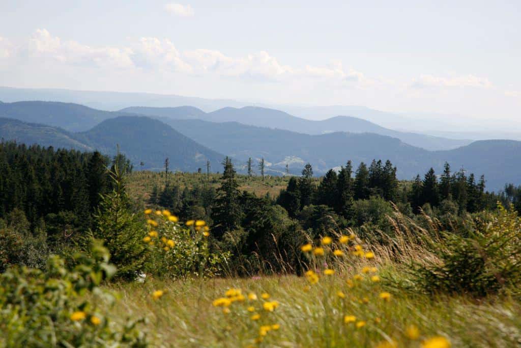
Huzenbacher Lake
by Ulrike Klumpp
Whether you walk the whole route in several days or opt for a single stage of the "Murgleiter", one thing is certain: Here you can take a deep breath in the truest sense of the word and relax in one of the numerous designated locations. Thanks to the healthy climate, the region has been the destination of guests looking for relaxation for generations. The air is pure, the climate is pleasant, and body and mind regenerate when you exercise in the fresh air. And along the way, sights and delicious Black Forest cuisine await you.
If you want, you can walk the Premiumweg in the opposite direction, because it is signposted in both directions with the "Murgleiter" diamond. Since the "Murgleiter" is connected with many access routes, the hikers can arrange the individual stages individually and flexibly. The connection of all hiking stages to the S-Bahn line of the “Murgtalbahn” is also practical and environmentally friendly, so that the How to get there is easily possible without your own car.
The individual route sections:
Start: Unimog Museum, At the B462 exit Schloss Rotenfels, 76571 Gaggenau
End: Schliffkopf plateau on the Black Forest High Road, 72270 Baiersbronn
1st stage from Gaggenau to Gernsbach
From the Unimog Museum in Gaggenau to the Gaggenauer Waldseebad (natural swimming pool), up to the Ebersteinburg ruins (magnificent panoramic view). Continue on the premium hiking trail “Gernsbacher Runde” uphill to the 668 m high Merkur. After descending towards Gernsbach, you reach the Träufelbachsee. From there it goes up again to the papermaking town of Gernsbach. Here the path leads through the old town to the end of the stage, the Gernsbach portal.
Length: 23,3 km; 1001 vertical meters up, 947 down - difficult, approx. 7,5 h.
2nd stage from Gernsbach to Forbach
On the Eberpfad towards Eberstein Castle, you first descend through the vineyards, then up to the Rockertwald (bizarre rocks and magnificent views from the Elsbethhütte and the Dachsstein), past the Fatima chapel into the pretty half-timbered village of Reichental. Further up through the Brunnwiesental (typical Heuhüttental), on steep paths down towards Gausbach. Along the Murg, the path leads over the historic wooden bridge to the end of the impressive second stage to Forbach.
Length: 24 km; 1221 vertical meters up, 1130 down - difficult, approx. 7 h.
3rd stage from Forbach to Schönmünzach
The start of the stage is the Forbach tourist information office up to the Marienkapelle - after an ascent on the Westweg, the moated castle and the impressive pipe run of the pumped storage power plant are reached. Via cozy forest paths to the Schwarzenbach dam, the largest reservoir in the northern Black Forest (boat rental). Following the course of the water from Schwarzenbach and Raumünzach, the path leads towards Murg, to its narrowest and wildest passages. The end of the third stage is reached over wooded slopes above the valley floor: Schönmünzach, the former border between Baden and Württemberg.
Length: 17,7 km, 893 meters uphill, 732 downhill - difficult, approx. 6 hours.
4th stage from Schönmünzach to Baiersbronn
After the start, the route runs over the Roten Rain to Schwarzenberg, one of the oldest populated places in the Murg Valley. This is followed by an ascent on natural paths with wonderful views and through deep forests to the deepest Karsee of the northern Black Forest, the Huzenbacher See. Past the Seltenbach waterfall and over the Kleemiss (high moor), it goes down into the Tonbachtal to Baiersbronn.
Length: 23,6 km, 920 meters uphill, 765 downhill - difficult, approx. 7,5 hours.
5th stage from Baiersbronn to the Schliffkopf
Length: 21,5 km, 974 meters uphill, 556 downhill - difficult, approx. 5,5 hours.
Practical information
Features:
Good and sure-footed footwear, weather-adapted, functional hiking clothing, possibly hiking sticks for rocky paths.
Safety Instructions:
Plan stages with appropriate breaks. Carry sufficient fluids with you. There are restaurants everywhere. In case of road closures due to forest work, it is essential to follow the signposted diversions.
Hiking without luggage:
There is also the possibility of enjoying the “Murgleiter” in a completely relaxed manner with the Murgleiter flat rate including overnight stay, luggage transport, food on the hike and a hiking map. The offer can be adapted to individual requirements on request.
Arrival:
Arrival by bus and train:
Stadtbahn Karlsruhe-Rastatt-Freudenstadt (S81 or S8) and various bus routes, detailed information under www.kvv.de and under www.vgf-info.de
Gäubahn Stuttgart-Singen, Eutingen-Freudenstadt, timetable information: In www.bahn.
Arriving by car:
BAB A5 Karlsruhe-Basel, exit Rastatt, continue via B462
BAB A81 Stuttgart-Singen, exit Horb, continue on B 28 via Freudenstadt
Hiking parking spaces and public parking spaces are available at the stage destinations.
Accommodations:
Along the route there is a multitude of overnight accommodations from simple rooms to 4-star S-Hotels.
Information:
Maps and literature
“Murg Valley” hiking map on a scale of 1: 25.000 (€ 4,90) and “Baiersbronn” hiking map in a scale of 1: 25.000 (€ 6,50) are both available from the Murg Valley tourist information office, the “Im Tal der Murg” association. (Tel. 07225 9813121) and Baiersbronn Touristik (Tel. 07442 84140). Also available at the appropriate locations: the free flyer “Die Murgleiter” as well as the Murgtal hiking guide and the Baiersbronn hiking guide.
Additional information
source
Lake Huzenbach © Ulrike Klumpp
Panorama dough © Ulrike Klumpp
Ground head © Ulrike Klumpp