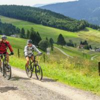
The L 123 road in the direction of WiedenerEck approx. 2.5 km to the large Rank. From there the road towards Ungendwieden. Left at the wayside cross. After a barrier, continue on the unmade road. Past the cattle gate.
At the fork in the road, turn right in the direction of Knöpflesbrunnen. At the next fork, follow the path straight ahead in the direction of Knöpflesbrunnen. Now slightly downhill to the refuge ~Auf der 5chanz" and on to the Dachsrain crossroads.
Choose the slightly ascending path towards Knöpflesbrunnen (blue rhombus). From the fork in the road, another 1,5 km to the very idyllic Almgasthaus Knöpflesbrunnen. Then take the same route back to the fork in the road. From there, continue along the path (panoramic path) that leads down to the left at the edge of the forest. After about 2 km the wide path climbs back up to “Dachsrain”. On the wide path (like the way there) to the refuge on the Schanz. Follow the signpost Winkelstüble Muggenbrunnl Oberhäuser half-right. After a short drive you reach the Gschwender Höhe (Hölzle). Take the path on the left towards Boden. At a large fork in the road at Wasserbüttenenden, turn left on a wide path to the “Auf den Boden” refuge. First orientate yourself on the red rhombus (west towards Feldberg). Shortly after the highest point of the tour, leave the path with the red rhombus and follow the blue rhombus direction Schauinsland consequences. Drive to the country road, turn right there. At the ski lift parking lot, leave the main road on the right and follow the natural path (blue rhombus). When the trail house (refreshment stops) is visible, turn sharply right.
Then follow the red rhombus further into the Langenbachtal. After a steep section, leave the Westweg (red rhombus) at the next fork. Continue cycling on the wide path that turns left. Coming out of the forest, the path leads down. Caution: about 100 m after the S-curve, the Trubelsbach must be crossed on the right. The nature trail in the direction of Muggenbrunn-Oberhäuser turns into a small asphalt road. In the Oberhäuser district, follow the nature trail that leads up to the "Gschwenderhöhe".
From there, after 200 meters down the valley, you will reach the fork in the path (see outward stage 0-3). On the way / road always downwards Wieden.


