Start: Todtnau
Kilometre: 238
Short description:
From the Wiesental over the Feldberg, past the Schluchsee and lazy lord; the romantic Steinatal down to Waldshut-Tiengen, fast the B 500 up to St. Blasien, through the Blasiwald Dead moss. The wild and romantic Wehratal down to Wehr, to Hornberg (past the ruins of Bärenfels) and back to Wehr, via Schopfheim, through the Kleine Wiesental to Tegernau. Past the blue after Badenweiler, Sulzburg, Staufen, through Munster Valley up - over the Wiedener Eck - to Utzenfeld, and from Utzenfeld via the B 317 back to Todtnau-Fahl.
Description:
the Schluchsee, the Steinatal, the Domanlagen of St. Blasien, the Wehratal, from Hornberg the view of the Alps and the Rhine valley, the Erdmannshöhle, the small Wiesental, the mining museum in Sulzburg, the old town of Staufen as well as the Münstertal and Wieden with the visitor mine Dark ground.
We start our tour at the Gasthof-Pension Lawine (where we stayed overnight while our machines were in the garages!)
... and drive over the B 317 up to the Feldbergpass. During these 4,5 km we overcome around 300 meters in altitude, which means that our machines reach their operating temperature very quickly. When driving over the pass we see a junction on the left that leads up to the Feldberg. Since the mountain is more for pedestrians, we cross the pass and drive down into the Bärental.
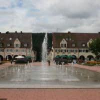
After 11 day kilometers we reach the first junction, where the road going off to the left leads to Titisee and the road going off to the right leads to Schluchsee. We turn right, following the yellow direction sign (B 500 towards Waldshut, St. Blasien, Schluchsee) and after 17 daily km we reach Schluchsee. Now we leave the forest area and the road now runs above the lake, from where we have a wonderful view down to the lake. We soon reach the town of Schluchsee. Here, immediately on the right, is the first gas station on our tour. In front of the gas station, Bahnhofstrasse leads down almost to the lake, and there are plenty of parking spaces available here. Since nothing can stop us in our morning enthusiasm, we drive past the town of Schluchsee to Seebrugg.
After 24,5 km we pay attention to the yellow sign and turn left towards Ühlingen, Birkendorf, Grafenhausen. Passing Faulenfürst we reach the Rothaus brewery after 28,5 km. The famous "Tannenzäpfle-Pils" is brewed here. But Tannenzäpfle and motorcycling are not compatible, and so we continue on this road in the direction Bonndorf. After about 35 day-km we reach the "Steina Valley", whereupon we reduce our speed a little, as there are tight and confusing bends here.
After 37 km, shortly before the bottom of the valley, we reach a sign that tells us that by turning right we reach Waldshut-Tiengen and Untermettingen. If you drive about 200 m further in the direction of Bonndorf, the “Steinasäge” inn is on the left. However, no one in the group signals signs of fatigue, so we turn right into the Steinatal - towards Waldshut. After 41,5 days we see the first house on the right of the road, the “Roggenbacher” inn - bikers welcome - with a beautiful garden restaurant and an animal enclosure. Something else strikes us: the first parking spaces on the left of the path are reserved for motorbikes! Those who take a break here can also stretch their feet and visit the castle ruins 200 meters away on the left of the Steina. After a cup of coffee, which we enjoyed in a friendly atmosphere, our motorbikes hum again.
30 m after our start at the “Roggenbacher” inn there is a sign that says that Waldshut is straight ahead, 20 km away. Further we roll down the beautiful Steinatal and 500 m further to the right we see a bulge, the castle ruins at the top left. But now the road demands our concentration. The valley is really romantic and there is enough work to do on the motorbikes. At 57 daily km we leave the forest area and reach Detzeln. From here it means free travel, past meadows and fields, until we have reached Tiengen. At a daily km of 63 km we reach a cross street, in which we turn right, in the direction of Tiengen city center (although the sign points to the left - direction Basel, Waldshut, Schaffhausen). Shortly afterwards we see an Agip petrol station on the right of the road. Remaining on this road, we roll past the train station after 70 day-kilometers. At 71,5 daily km we see a traffic light in front of us. Arranging on the left, you continue in the direction of Titisee and houses. It is the B 500, which immediately after the traffic lights - clearly visible - leads over a bridge and then up the slope to the right between the houses. The four-lane B 500 leads to the Black Forest heights, then past the “Waldhaus” brewery, towards the towns of Häuser and St. Blasien. On these 20 km or so, our machines finally get the “air” they deserve to breathe deeply.
After we can read 92 daily km on the speedometer, we see a sign at the entrance to Hütten: St. Blasien left. Houses has something special to offer: There is a pumped storage power plant in the house, which can be visited. Anyone who is interested should be told that this is only possible on Thursdays at 14 p.m. Since the tour through the power plant including the supporting program takes about 2,5 hours, this is a program point for another tour.
So – we go down into the “Albtal”, where after another 2 kilometers we reach St. Blasien. Now we have the choice of either staying on the road and continuing to Todtmoos or turning right (after 100 m there is a gas station) to drive into St. Blasien and visit the very interesting cathedral and the cathedral grounds - there is plenty of parking space . Anyone who enjoys classical music should inquire about the cathedral concerts. Stop or no stop – we continue along the bypass road to day km 95, which is roughly the city center. There is a sign here showing the road to Todtmoos, Dachsberg or Ibach indicates. Via this road we reach the center of Todtmoos after 111 day-km. There are two more options here: If you don't like it anymore, turn right, over the "Hochkopf" down into the Wiesental and after another 25 km return to the cozy "Avalanche" or - if it's still fun - turn left and down to Bad Säckingen or Wehr through the wild and romantic "Wehratal".
Turn signal left and off into the Wehratal! After 116,5 day km we reach Todtmoos-Au and see a large sawmill on the left in front of us. Directly opposite is the “Klondike Inn”, a popular meeting place for motorcyclists. 50 m further on we see a sign that says straight ahead to Wehr for another 12 km, then right to Schopfheim via Gersbach for another 22 km. We continue straight ahead and soon afterwards roll through the deeply cut gorge of the Wehra. Attention: Damp asphalt is to be expected here, as the sun no longer reaches the valley gorge everywhere. With a daily mileage of 125 km we roll through a tunnel and immediately afterwards we see the Wehratalsperre on the right of the road. 1,3 km further we are at the dam, and here we read that this is a pumped storage power plant. This basin here is the "lower basin", the upper basin is at Hornberg. We want to go to the place later. Over this relatively short distance you have reached a height difference of 600m. The turbines and pumps are located in a cavern in the mountain. We continue rolling and after 16,4 km we reach weir.
At 17,2 miles, we see a junction in front of us, which is signposted as follows: straight ahead towards Schopfheim for 8 km, left towards Bad Säckingen for 11 km or to the city center. Turn indicator left and off we go into the city until after about 800 m and a traffic light we see a sign again, which tells us that we are going left to Görwihl, Rickenbach, Hornberg and Hütten. We follow this road for about 3,5 km until we reach a junction. On a sign it is written that it goes left to Hornberg and Hütten. So turn left, and after another 3,2 km we reach the village of Rüttehof. On the signpost here it is indicated that you turn left after 11 km to reach the town of Herrischried, after 4 km the town of Hornberg and after 3 km Atdorf. So turn left, but the next signage is 1,1 km further on. On it we read: straight ahead towards Herrischried 10 km, and after Hornberg another 3 km. We continue straight ahead in the direction of Hornberg. After another 1,5 km the road splits again. On the sign attached here we read: Straight ahead in front of us is Herrischried 8 km away and the aforementioned Hornberg reservoir. However, if you turn left, you come to Hornberg after 1 km. We turn left to Hornberg and stay on this road, also through the village, until after 140,3 day-km the “Jägerstüble” inn is on the left in front of us.
This is where the road ends, and we have a wonderful view over the Rhine Valley all the way to the Swiss Alps. We sit on the garden terrace and enjoy the wonderful view with a cup of coffee. We drive back the same route until we reach the B 518 again in Wehr. Now go right away, towards Schopfheim. After leaving Wehr, at daytime km 154,6 we see a sign pointing to the right to the “Erdmannshöhle” of Hasel. This cave is one of the oldest and most beautiful stalactite caves in Germany. If you want to get to this stalactite cave, you drive about 1 km into the village and then turn right once. Then you can see the parking spaces in front of you after about 1 km. Since we know the cave, we continue on the B 518, over the sloping southern flank of the Black Forest to Schopfheim, where we arrive at the edge of the village after 163 km. If you want to break off the route here, you get directly onto the B 317 and come, in the direction of Donaueschingen, through Zell or Todtnau, after approx. 35 km back to the “avalanche” in Todtnau-Fahl.
We had a lot of fun on the varied routes and the wonderful landscape and continue through the Wehrastraße towards the city center. We cross the following roundabout, drive into the 30 zone, cross a railroad crossing and after 1 km come to the city center or turn left to the market square. We continue, past the market square, in the direction of the southern outskirts, the district of Gündenhausen. There are also gas stations here again. At daily kilometer 165,7 we roll into a roundabout, which we leave to the right in the direction of Neuenweg, Tegernau, Langenau. Now our route leads us through the Kleine Wiesental. We drive through Langenau, turn left in Enkenstein. In Wieslet we follow the signpost - right to Neuenweg 14 km. After 175 km we reach the town of Tegernau, where a sign shows us that you can reach Badenweiler after 19 km via the road leading to the left. Off to Badenweiler.
After 1,5 km we roll past a quarry. From here to Badenweiler you should enjoy the road with caution! It becomes narrow, confusing, in parts it is also dirty and, last but not least, it leads along northern mountain slopes, which means that it is often wet until late in the day. But that doesn't shock us, we pack the two large gears as ballast in the backpack and the machines hum forward. After 184 day-km we reach a hilltop with a large rest area above the village of Stockmatt. We are now at the “Blauen”, which with its 1165 m gives the Black Forest on its western flank another impression. There is also an emergency telephone here. From this resting place the road leads down to Badenweiler or into the Rhine Valley. Even now, full throttle is capitalized. After 193 day-km we come to a sign, "Badenweiler right - Kandern left". However, Badenweiler is temporarily closed to motorcycles. We turn left here - towards Kandern. After about 1,5 km we reach another cross street, where it turns right to the BAB, to Müllheim, Schonau and Niederweiler goes. We branch off to the right and after 3,5 km we reach Niederweiler, where we branch off to the left in the direction of Müllheim.
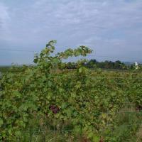
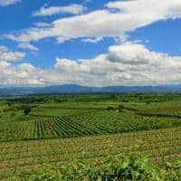
After 202 day-km we come to the outskirts of Müllheim and turn right at the first possibility towards Zurzingen, Britzingen and Sulzburg. At the next junction, after about 300 m, we turn right again, continue to Zurzingen, Britzingen and Sulzburg. Now the road leads us through huge corn fields to Zurzingen. Rolling further in the direction of Sulzburg, we then pass vineyards in the romantic wine town of Britzingen. On the main road we cross Britzingen and after 2,5 km also the town of Laufen. Finally we come to a junction which leads to Sulzburg on the right. In Sulzburg we drive to the center of the village, which we reach after 212 km. A very interesting mining museum can be visited here. After visiting the mining museum, we leave Sulzburg again, in the direction from which we came. If you do not drive to the left at the end of the village, but follow the signs to Heitersheim, you have to drive an arch in Dottingen to get to the road to Staufen. After 113,5 km we see a sign on the road, which tells us that Staufen and the Münstertal are straight ahead.
About 1,5 km further on we come to Staufen, and 500 m later the “Münstertäler Straße” lies across in front of us. Directly on the opposite side of the street there is a sign on which the direction of travel is to the left Freiburg or to Bad Krotzingen and the direction of travel to the right to the Münstertal or to Schönau is indicated. Our route leads us towards Münstertal. Since we want to have a look at the wonderful city center of Staufen, we immediately move into the left lane again after approx. 150 m and roll to the parking lot in front of us on the left. Staufen has a very beautiful, impressive old town center. After we have rested a little and got back to the machines from the old town, we leave Staufen in the direction of Münstertal. On the overland route that now follows, we see the Belchen massif slightly to the right in front of us. We cross the town of Münstertal via the main road, where a sign indicates a visiting mine in a right side valley. In the middle of the Münster valley is the St. Trudpert monastery, some of which can be visited. In the village of Münstertal we also find several petrol stations and towards the end of the village we see the "Schauinsland" slightly to the left in front of us.
As soon as we have left the village, the road leads us towards Schönau. Through many hairpin bends and curves and through a very attractive landscape, it meanders up the western flank of the Black Forest to the "Wiedener Eck".
Over the Wiedener Eck we drive down through the Wiedener Valley. If you still have some time and are interested in a mine: There is definitely a very beautiful visitor mine on this route, the “Finstergrund” mine! Here you are still often guided through the mine by the old miners who once worked here until it was closed. After 249 km we reach Utzenfeld. Arrived on the main road, we branch off to the left and after 2 km we reach the federal road 317. At the B 317 we turn left and after about 10 km we reach the Gasthof-Pension “Lawine” in Todtnau-Fahl.
With around 260 kilometers driven as well as around 3150 meters of ascent and 3150 meters of descent, we traveled through some of the most beautiful valleys and landscapes of the southern Black Forest on this tour. The Gasthof-Pension "Lawine" is very centrally located on the southern ascent of the B 317 to Feldberg - in the middle of the southern Black Forest and is therefore an ideal starting point for this and other tours.